

 Data
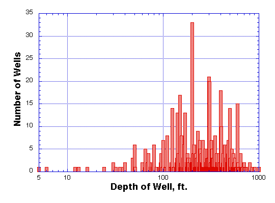
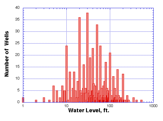
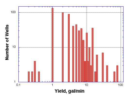
provided by the State Engineer's office for over 600 wells drilled in the Planning
Area reveal an average depth of slightly over 293 feet. According to these records,
well-water levels averaged 62.3 feet and well yields averaged 6.24 gpm. Depths
of over 900 feet and well-water levels of over 400 feet have been encountered
(Table 3.2). According to Ground Water Systems' Dick Williston, a Boulder-based
driller who completes over 80 percent of the wells in the Planning Area, only
2-3 percent of wells come up dry. Histograms display the distribution of well
yields, depths, and well-water level (Figures 3.3 to 3.5). According to drill
records, the vast majority of wells drilled in the Planning Area are for household
use. A few exceptions may exist for minor irrigation and fire protection use,
but well yields generally are not sufficient for these more intensive uses.
Data
provided by the State Engineer's office for over 600 wells drilled in the Planning
Area reveal an average depth of slightly over 293 feet. According to these records,
well-water levels averaged 62.3 feet and well yields averaged 6.24 gpm. Depths
of over 900 feet and well-water levels of over 400 feet have been encountered
(Table 3.2). According to Ground Water Systems' Dick Williston, a Boulder-based
driller who completes over 80 percent of the wells in the Planning Area, only
2-3 percent of wells come up dry. Histograms display the distribution of well
yields, depths, and well-water level (Figures 3.3 to 3.5). According to drill
records, the vast majority of wells drilled in the Planning Area are for household
use. A few exceptions may exist for minor irrigation and fire protection use,
but well yields generally are not sufficient for these more intensive uses.
 |
 |
Data compiled in the 1980 Water Resources of Boulder County study showed crystalline-rock aquifers are the most difficult aquifers in the County from which to obtain sufficient water for domestic uses. Population of the mountain areas of Boulder County during the 1980 Water Resources study was about 7000 people. 1997 population is 12,119 in the incorporated areas (Nederland, Ward, Jamestown, etc.) and 10,440 in the unincorporated portions of the County. Several sources (County, private realtor) suggest that growth potential for the mountains of Boulder County is 20 to 50 percent for unincorporated areas and 100 percent or more for some of the mountain towns. This information is presented because the primary user/well-driller in the Planning Area and the primary cause of pollution and potential pollution of both surface water and ground water is the mountain residential waste-water treatment system (Hall, Hillier et al. 1979, 1980, 1981; Burns, McCrumb et al. 1973).
There are about 350 family units in the Planning Area. Densities of housing range from 1 home on several hundred acres (generally older agricultural/ranching) to 3-4 acres/lot in Aspen Meadows, to as small as 2.7 acres/lot in the Lazy Z subdivision (Boulder County Land Use). Studies done in Evergreen and Estes Park show a general link between housing density (i.e., density of residential septic systems) and ground/surface water pollution. Age of community, average lot size, slope of land surface, composition, permeability, and thickness of surficial material, density, size, and orientation of bedrock fractures, maintenance of waste-water treatment systems, and the presence of animals (domestic and wild) were cited as factors contributing to degradation of groundwater. Generally, older communities show greater pollution problems (Hall, Hillier et al. 1981; Burns, McCrumb et al, 1973). In the Evergreen studies, comparisons of three small communities showed that water pollution problems were least in the communities with average lot sizes of 3.5 acres, greatest where lots averaged 1.2 acre, and moderate on 1.8 acre/lot. Age and maintenance of the septic systems are also a factor. In the Evergreen study, fractured crystalline-rock provided many of the wells for residential use (a few domestic wells are sited in alluvial deposits). Average altitude of the Evergreen study was 7400', slightly lower than the average Planning Area altitude. Average well depth was similar to the Planning Area. Maintenance and design standards of septic systems were cited as the major causes of pollution from residential septic systems.
Aeration-treatment tanks, a method of pumping air into septic tanks to increase the rate and effective breakdown by bacteria of harmful waste products, are often more problematic than beneficial. Without maintenance and monitoring, the pumps wear out and may not be replaced. The system then becomes similar to or worse than a standard septic/leach field system. The Boulder County Health Dept. estimates less than one percent of the septic systems in the County are aeration-treatment systems.
Agricultural uses of land in the Planning Area are presently limited to livestock. Hay raised for cattle and horses has rarely, if ever, been produced on irrigated land (Stilson, personal communication). Some ditching has been done to redistribute natural flows, and stock ponds have been created in several locations. Agricultural activity probably took place on less than 15 percent of the surface area of the Planning Area at any time during the last 150 years. Presently about 5 percent or less is dedicated to stock.
Water use in these remaining agricultural areas is probably not augmented by pumping groundwater except in the very driest years. When local hay crops are insufficient during dry spells, feed is generally imported or herd sizes reduced. Five of the thirteen registered water rights are designated for irrigation purposes. According to local ranchers, it is unlikely that any great amount of water is pumped purely for agricultural use.
It is unknown how many of the residential wells may be used for light irrigation duty, such as gardens, or for small stock herds (there are many equestrians in the Planning Area with 1 to 4 horses).
Generally, the quality of water in the mountain aquifers is more suitable for a drinking water supply than plains aquifers (Hall, Hillier et al. 1980). Activities such as mining, farming, disposal of industrial/municipal wastes, and ranching usually increase the specific conductance of water, especially surface water. These uses and the specific conductance as indicator of general water quality1 typically increase from the mountains to the plains.
Current drinking water standards for human health (Colorado Dept. of Public Health and Environment, Water Quality Control Division) are listed in Appendix 3.3. It was estimated that 14 percent of wells in the crystalline-rock aquifer were very likely to exceed the standard for dissolved solids (500 mg/L). Nine percent of mountain wells may exceed the standard for sulfate. Three samples showed excessive fluoride. Most wells containing larger concentrations of chloride and nitrite are located near leach fields, however the standard for chloride was exceeded in only 4 mountain wells among 169 tested. Three samples from mountain wells showed detergents present (foaming agents). These are not natural contaminants and are therefore indicators of contamination from domestic wastes. None of these samples exceeded the water quality standard.
There was an apparent increase in nitrates found in the mountainous portion of Boulder County from 1976 to 1996. Nitrate is typically associated with sewage and animal waste, and high concentrations in drinking water can be detrimental to human health. It is possible that the results were an artifact of the small sample size (10 wells were sampled).
In 1976, 19 percent of mountain wells tested exceeded 1 coliform bacterium/100 mL, 5 percent exceeded the standard for fecal coliform. In 1996 the rate of detection of coliform bacteria increased 800 percent county-wide. Authors of the 1996 study (Bruce and, O'Riley, 1997) caution that trends may not be statistically significant in only two data sets (1976, 1996), however, another study in a comparable area (Hall and Johnson, 1979) found that disposal of domestic wastes was causing degradation of groundwater quality. The only samples (from a single well) taken from the Planning Area in both the 1976 and 1996 studies showed no exceedances. The 1996 study showed several statistically significant changes, including nitrate and coliform concentrations in mountain portions of the County that increased from 1976 to 1996. However, conclusions were uncertain regarding the increase of coliform.
The Boulder County study showed a direct correlation between well-to-leach field distance and contamination with coliform bacteria. There was a consistent contamination rate at distances up to 200 feet and a substantial reduction in contamination rates at distances over 300 feet. In addition, a study done in a similar mountain area (Completion Report Series #32, 1972) showed that tracer bacteria introduced in the ground water were found to traverse a horizontal distance of 94 feet to a sample well within 24-30 hours. This study recommended that at mountain building sites, "hydrogeologic data, such as bedrock fracture patterns, depth and movement of ground waters, seasonal fluctuations in ground water levels, be fully ascertained prior to installation of [septic systems]."
Hall, Hillier et al. 1981 pointed out from their data that the distance from well to leach field corresponded to contamination rates: wells less than 200 feet from septic systems had a 29 percent or higher coliform contamination rate; wells between 200-300 feet from septic leach fields showed 22 percent contamination rate; and wells at greater than 300 feet from a leach field still showed a 12 percent coliform bacteria contamination rate. Based on these data, if every home in the Planning Area had a well-to-leach field distance of 300 feet (two to three times the required distance), approximately 40 families would still be affected, and as many as 70 wells in the Planning Area would prove contaminated. In fact, a study by the Colorado Geological Survey undertaken in a location similar to the Planning Area concluded that approximately two-thirds of presently used water supply wells show some form of pollution from leach fields (Wright Water Engineers, 1995).
Records obtained from the Colorado Department of Public Health and Environment, Water Quality Control Division, showed that at several sites tested during the 1976 Boulder County studies, all four wells tested in the Magnolia area contained elevated levels of magnesium and zinc. Excessive magnesium may have a laxative effect and may impart an unpleasant taste to the water. Excessive zinc may impart a bitter or metallic taste to the water. The four groundwater sites near the Planning Area were analyzed as part of the Boulder County Water Resources (Hall, Hillier et al. 1980) and two metals (magnesium and zinc) were consistently high in all four samples, ranging from 2600 to 8900 mg/L (magnesium) and 60 to 8300 mg/L (zinc). State standards are not set for magnesium, but zinc standards are set both for secondary drinking water (at 5 mg/L) and agricultural use (2 mg/L).
Based on conversations with the US Geological Survey (Jim Otton, personal communication, 1997) uranium is rarely a problem in the Planning Area, as there are few, if any, uranium occurrences. If there are, they are likely to occur in the vicinity of mine wastes. Uranium does tend to concentrate in fractures in the crystalline-rock of the Planning Area (the same locations where water is usually found), therefore it could occur where water is extracted for domestic purposes. EPA proposed 20 ppb U as a maximum contaminant level, but this proposed standard was rejected by Congress.
Radon, on the other hand, is more commonly present, although there are presently no drinking water standards. Radon in drinking water is not a well-documented health risk, but it does contribute to radon in air, a known risk. It has been shown that radon originating from the water supply can contribute up to 36 percent of the concentration in indoor air. Investigations in the mountainous portion of Jefferson County showed that radiochemicals in the water may be a health hazard (Hall and Johnson, 1979). Others have shown indoor air levels at 1200 Pci/L derived entirely from the water supply. According to Lawrence et al. (1992), radon concentrations do not correlate with variations of other dissolved contaminants. In addition to this unpredictability, radon concentrations show a tendency to fluctuate over time, perhaps as a result of seasonal water-level fluctuations or pumping stresses. Congress attempted unsuccessfully to set 300 Pci/L standard for drinking water supplies. USGS's Otton stated that radon is fairly common in residential water supplies and the mountains of Boulder are no exception, with samples ranging typically from 1000-4000 Pci/L, minimums around 60 Pci/L, and observed maximums exceeding 14,000 Pci/L.
No mill sites were sampled during the Boulder County radon survey conducted as part of the 1995 Radon Contract for the Boulder County Health Dept. Environmental Health Program.
Mining effluent was tested as part of the Colorado Geological Survey's Abandoned Mine Land Inventory and the Inactive Mine Inventory. Only one water sample was taken in the Planning Area and the mine drainage showed significant iron and copper.
Geologic reviews completed as part of this MEPP report suggest the potential for cyanide leachate used in the process of gold milling at or near the Magnolia townsite as part of the mining activities before and near the turn of the century. Samples of mine drainage were not taken on many private sites in the Colorado Mine surveys. This may prove a worthwhile project in the future.
1 The standard of 500 mg/L for dissolved solids will probably be exceeded when the specific conductance is greater than 735 micromhos, the standard for sulfate (250 mg/L) when specific conductance exceeds 840 micromhos, the standard for magnesium (225 mg/L) above 2500 micromhos. The predominant specific conductance of water from crystalline-rock aquifers in the Planning Area was generally between 250-500 micromhos, and in glacial alluvium less than 250 micromhos.
 |
 |