Preserve
Unique Magnolia
| January
1998 Newletter |
Volume
4 Issue 1 |
inside...
Early
Travel in the Magnolia Area
by Lucas Koepke
Some
of us may like to think that we lead a fairly rugged life. We hop into our four-wheel
drive sport-utility vehicle and take all of 25 minutes to drive to Boulder.
Well if rugged is what you're after, you are several decades too late. Imagine
what it was like in the early part of the century when a trip to Boulder from
the Magnolia area required an overnight stay in a boarding house because a round
trip typically could not be done in one day. You think Magnolia road is steep
now? Picture it without any switchbacks, chock full of muddy ruts, and not a
guardrail in sight..
When automobiles were first invented in the 1890s, they were
so unusual that circuses displayed them as part of the program. Early automobiles
had great difficulty navigating the rough trails and paths that were called
roads. These vehicles were unreliable and required frequent repairs (similar
to some vehicles I've seen today). Therefore the majority of the population,
including the early Magnolia road residents, continued to rely on horse-drawn
wagons well into the 20th century. In our neighborhood, horse-drawn wagons and
horseback were the standard modes of transportation in the early 1900s as cars
and trucks couldn't handle the steep roads, mud, and deep snow.
Before 1871, Boulder Canyon stopped at the Magnolia turn-off and did not continue
as a road to Nederland. The road up what was then called Magnolia Hill was constructed
prior to 1850, with much of the serious retaining walls and work done around
1865. The road remained unpaved until the 1970s; today the road is still dirt
after the first 4.5 miles of pavement.
Early Magnolia road took a very similar path to its present-day route except
that it didn't bother to wiggle back and forth as it went down steep grades,
rather it just went straight down.
The early road was very difficult for automobile traffic
as it was either rock or dirt, which turned to mud every time it rained. Cars
would often become stuck and sink into the mud or get hung up on the slippery
rocks. A good team of horses, however, had enough strength to pull a wagon through,
and out of, the muck. Another disadvantage for cars was the snow. In the
winter snows Magnolia was often impassable, as it was never plowed. The severity
of the road meant serious isolation for the few families who lived in the Magnolia
area. Long winters made these pioneers very self sufficient. The farming and
ranching families who lived in this area stored up food and firewood during
the summer months so they could survive the winters. During the winter months
road travel was restricted and ore wagons were the sole travelers on the roads
to Boulder.
The ore wagons could go down to Boulder either by way of
Magnolia road or over Flagstaff. That road, remnants of which are still visible,
ran from upper Magnolia all the way down Gregory Canyon until it connects to
Baseline Road at the foot of Flagstaff. This route was never used by automobiles,
but was used frequently to drive cattle to Boulder and on to Denver. Its original
intent was not for access from the mountains to the plains, rather it was to
connect the eastern parts of the county (Valmont area) to the thriving casino
towns of Black Hawk and Central City! Both the Magnolia to Boulder Canyon
route and the Flagstaff route were one-lane roads except for an occasional wide
spot so that the ore wagons could pass each other. The ore horses pulling
the wagons would wear bells on their harnesses to warn other drivers to pull
over and let the loaded wagons by.
When the mines shut down and the ore wagons stopped running,
the road was used more and more by ranchers. The road was reconstructed
with automobile use in mind. It was not until these improvements were made,
around the 1950s, that Magnolia residents bought cars; this was the first time
they were of any use for transportation. As time went on and more traffic used
the road, it was widened to two lanes, switchbacks were put in, and eventually
guardrails were installed. Clearly Magnolia road has changed over the years.
The road we enjoy today, part pavement and part well-graded dirt, is a far cry
from the one-lane mining roads our neighborhood ancestors used.
Now, as things continue to change and our neighborhood continues
to grow, what does the future hold for Magnolia road?
See Related article inside.
ABOUT THE AUTHOR:
Lucas Koepke has lived
in Nederland for eleven years. He enjoys hiking, biking, cross-country
skiing, camping and other fun stuff. Lucas enjopys living in the mountains
and playing with his dog Max. Lucas has known long-time Magnolia resident
Edith Scates for over six years, often helping out on her ranch, and used
her as a source for this article.
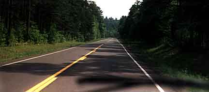
The
Right Direction?
Some change
is inevitable. Even up here in our quiet community, the pressure of increasing
growth in Boulder County is being felt. While a common response to the
increasing growth in rural areas like ours seems to be to urbanize them
and, over time, remove the very characteristics that drew us here in the
first place. One hint at the possible urbanization of Magnolia is some
peoples desire to pave the road. Aside from the aesthetic value the dirt
road adds and the depth of character it provides to our community, staving
off pavers may have some safety benefits for all of us. The question is
clear: how would paving the road affect the following data?
The
Colorado State Patrol data on Magnolia Road accidents from 1990 through
September 1997 reports the following: Of the 109 accidents on or near Magnolia
Road recorded over the last seven years, speeding was cited as the most
frequent cause and accounted for 40 percent of those accidents with inattention
to driving accounting for 23 percent. The cause of six accidents was
"wrong side of road" and 13 were caused by improper mountain driving.
Colorado State Patrol also reports that 50 accidents occurred on the unpaved
portion of upper Magnolia between mile 4.5 and mile 12 and 15 accidents
occurred on the paved portion of lower Magnolia. The balance of the
reported accidents actually occurred on Highway 119 where it intersects
with the base of Magnolia. In terms of density per mile there were 3.33
accidents per paved mile vs. 6.66 per unpaved mile.
Does
this nearly double rate of accidents per mile on unpaved roads tell us
that pavement is safer than dirt? Not necessarily.
The steepness and tight curves make excessive or unsafe speeds harder to
reach on the lower portion (although some people still drive dangerously). It
seems more common that once the steep section of the road is over and the openness
of Twin Sisters Valley is reached, speeds tend to accelerate. In spite of the
washboards, dust, and closeness to peoples homes, few drivers seem to respect
or even acknowledge the posted 30 mph sign. Not surprisingly, the slight curve
around mile 5 at the Twin Sisters intersection accounts for 8 percent of all upper
Magnolia accidents.BR> Eleven accidents (10 percent) happened
at Dead Man's Curve. This is the sharp curve at approximately mile 8;
it is well known and, incidentally, well marked with a 15-mph warning sign. Is
it reasonable to assume that speeds and perhaps accidents and injuries will only
increase if road conditions are improved? According to state records, people drive
faster on pavement, and speeds increase again each time a road is repaved. However,
pavement is not an easily isolated factor. When a road is upgraded, other changes
are always made. For example, tight turns are straightened for the expected increase
in speeds, intersections are given longer sight-distances by removal of trees
or berms, additional signage appears, and guardrails may be added.
Perhaps
the issue should not center on to pave or not to pave but should instead
focus on the quality of life that drew so many of us here. It is a luxury
to run or walk on these roads and expect little traffic. It is startling
enough when an occasionally vehicle speeds by, it would be a lot less fun
if if a walk on Magnolia started to feel like a walk in Boulder Canyon.
As it stands now we enjoy
a unique community setting here. We bought our homes when the roads were
dirt and with driveways that we knew wouldnt always be driveable. We liked
the fact that street lights didnt creep into our bedroom windows every
night and that traffic noise was a problem for our Boulder brethren.
Why
now, when we are coming together as a solid community that is proud of
its special neighborhood do we want to dress ourselves up in the urban
guise from which we profess to distinguish ourselves? Magnolia road will
probably be paved some day. The valley view you now have as you drive home
may some day be obstructed by a home or two. Until that time however, lets
preserve the unique Magnolia that so many of us call home.
UPDATES
. UPDATES .
UPDATES
Gross
Reservoir
The Gross Reservoir
draft management plan is currently in a 90-day review period. During this time,
all stakeholders will have an opportunity to comment on the plan. PUMA participants
in the recreation working group felt that some of the concerns expressed by the
group were adequately reflected in the draft document, but our desire to see no
net increase in recreational use is not emphasized as strongly as would have liked.
Of primary concern is to what degree the integrity of the document as it now stands
will be preserved when a management entity is contracted to oversee implementation
of the plan.
After this review period ends Gross Reservoir
consultants will need to incorporate comments and changes and then submit the
entire final draft to FERC for its approval. We will not be informed of comments
made during the review period nor will we see how those comments change the management
plan that FERC (Federal Energy Regulatory Committee) will review.
If you are interested in reviewing any of the management
plan documents or studies, please call Mary Scheller at 415-0910. We will keep
you posted.
68J
Things have
been pretty quiet on 68J this winter. Helping the county with signage and spur
road closure seems to have made a significant difference in the amount of abuse
previously experienced in the 68J corridor. Boulder County still plans to bring
in large boulders to further reduce illegal traffic on spur trails. PUMA volunteers
will monitor activity in that area again in the spring. At that time, the working
group will reconvene and assess the success of the project to date and determine
what, if anything, remains to be done.
Thanks to the many volunteers who
monitored 68J and Winger Ridge areas over the summer. These data have been compiled
and summarized and will be included in the MEPP report.
Other
Important Stuff
CARPOOLING
If you are interested
in carpooling or ride sharing with any of your Magnolia neighbors, contact Bonnie
Sundance at 442-2625 for ideas and suggestions on how to get something together
in your area or just to find out if any one who lives near you may also like
to pool driving resources.
OPEN SPACE MANAGEMENT
PLANS
If you would like
information about or would like to comment on management plans for the Reynolds
Ranch and Roger Phipps areas,
please write to:
Boulder County
Parks & Open Space
P.O. Box 471
Boulder, CO 80303
attn: Reynolds Ranch
Public input is welcome.
The careless editor
of this newsletter printed the wrong address last issue: SORRY. Check out our
webmasters excellent work at: www.peaknet.org/webpages/puma.
If you are at a Peaknet comuputer (B&F), you can find us under the Environment
section on Peaknets home page.
LIGHTNING ELIMINATORS
It is not too long
before we are throwing our fried faxes out the window again. If you want to
try to avoid this and are interested in a 15% discount, contact Bay Roberts
at 447-8836 for information on Lightning Eliminators and the surge protection
systems they offer for this lightning-prone area.
WHAT DO YOU
THINK?
Letters
to the editor are welcome.
USFS
10-Year Management Plan
The
long-awaited US Forest Service Revised Forest Management Plan arrived just before
the end of the year. With it came some concrete evidence that PUMAs efforts
for a resident-directed future for the Magnolia area are paying off.
By law the Forest Service must revise its forest management
strategies every 10 to 15 years. PUMA originated in late 1993 when the
local Forest Service District presented its initial proposed management plan
for Arapaho-Roosevelt National Forests. A majority of the Magnolia area is publicly
owned and PUMA members realized that our local knowledge would be valuable in
assessing the impacts of the proposed management plans.
Many studies were conceived by PUMA and several lengthy documents
were prepared for the Forest Service's consideration. PUMAs Micromanagement
survey presented appropriate forest management alternatives for the entire Magnolia
area. This report was prepared with the input of many residents and pointed
out several deficiencies in the government's proposal. We are happy to report
that the final publication of the USFS's Final Environmental Impact Statement
has adopted many PUMA recommendations. For those of you who have received
a copy of the document but don't have the time to browse the approximately 1031
pages plus maps, the "meat" of management prescriptions covering our area are
found in the portion titled 1997 Revision of the Land and Resource Management
Plan.
Magnolia is covered under two sections: Sugarloaf and Thorodin
geographic areas on pages 100-109. Here are a few of the critical directives
from these pages:
Restore, maintain, or enhance mountain grassland and aspen communities on an
opportunity basis. Manage ponderosa to emulate conditions representative of
nonlethal understory fire regime. Emphasize old-growth recruitment and retention...
Minimize human-wildlife conflicts in winter and spring...by closing area roads
to all motorized vehicles, including snowmobiles...
Manage for year-round recreational use. Minimize recreational impacts to riparian
areas and other sensitive habitats... The area along County Road 68J may
be closed to overnight camping.
Motorized travel will continue on some of the existing 4WD roads. There may
be significant road closures and obliterations to restore important meadows,
wildlife winter ranges, and flora and fauna areas."
Prohibit camping within 100 feet of lakeshores, streambanks, and trails.
Provide an area with minimal human-wildlife conflicts on a year-round basis
by limiting access to nonmotorized use only in the area between Winiger Gulch
and South Boulder Creek.
Motorized travel will continue on a seasonal basis on some of the 4WD routes.
Most of the trails in the area will be retained. There may be significant road
closures and obliterations to help restore important meadows and wildlife winter
range particularly in the vicinity of Winiger Ridge.
Manage recreational uses and road and trail networks to reduce erosion or deterioration
of riparian areas and watershed conditions. Evaluate road and trail impacts
to aquatic and riparian ecosystems...
Among our concerns that bear continued watching:
Timber harvest may be used to accomplish these goals.
Consider the disposal of isolated tracts of National Forest System lands in
the Sugarloaf and Magnolia areas.
PUMA is proud of its efforts to contribute to this significant
document and is excited to have enjoyed a productive working environment with
the USFS as well as a tremendous opportunity for learning.
>If you are interested in obtaining a copy of any portion of the Final Environmental
Impact Statement, write to:
US Forest Service
2995 Baseline
Boulder, CO 80302
The final document is available
in both paper and digital formats (except for the maps). Several PUMA members
have copies of the entire document and would be happy to share them with other
interested residents. Contact Bay Roberts at 447-8836 for more information.
Thanks, from the wildlife committee
Many thanks to all of you
who have so faithfully reported your monthly wildlife sightings for compilation
and to those who have called with specific sightings they thought would be
of interest--they were! And special thanks to the many great volunteers who
spent about 20 hours in the field this summer, participating in our Breeding
Bird Survey. Regular inventory participants this year have been:
Marianne Stilson, Kathy and Lee Teuber, Paula Hendricks and Norman Lederman,
Bay Roberts, Rob and Ananda Ellis, Sandy McMannis, Vivian Long, and Scott
Reuman.
PUMA members Ann Skartvedt, Jim Wolf, John McClellan, Dorene
Leonard, Jennifer Stewart, Bay, Rob, Marianne and nonmembers Steve Jones,
Scott Seevers, Maggie Boswell, Tom Delaney, Ruth Carol Cushman, Janet Chu,
Naseem Munshi, Mike Tupper, Barbara Beal, Mike Figgs, Dave Hallock, Pam Piambino,
Joel Hurmance, Ann Cooper, Paula Hansley, Elaine Hill all worked on the Breeding
Bird Project in conjunction with a number of our friends from BCNA and Audubon
societies. The success of the project is due to the hard work and commitment
of each one of these volunteers.
After the December reports are in, a 1997 sighting list
will be put together for distribution. Copies of the Breeding Bird Survey
will go to participants and will be incorporated into the MEPP plan. The overall
results will be summarized in next newsletter for all residents.The wildlife
survey is an ongoing project and everybodys input is a big help. If you have
a sighting you would like to report or would like to learn more about the
project please contact Cherie Long, Wildlife Committee Chair, at 447-0922.
Home |
Our Mission |
Working-Groups |
Mountain-Living |
Newsletter |
Magnolia-Chronicles |
Issues |
Community |