
PUMA instituted the Magnolia Wildlife Inventory in 1995 and the inventory continues to this day. The methodology is quite informal, consisting of reports from area residents to a central source (Cherie Long) on a monthly basis, giving dates, species and numbers seen, and locations, together with any specific identifying characteristics of the animals reported. Long totals the sightings, taking into account the dates, places, and characteristics reported (e.g. if a herd of 140 elk are reported by six people at the same approximate place on a given day, the total for that day would be 140. If 6 buck deer were reported on one day and three does on another, the total would be nine mule deer. In general the highest number sighted is that reported for the month). While this method is more accurate for the more visible species than for others, as the years have progressed and the number of reporters increased, it has aided in understanding those wildlife species, helped target critical wildlife habitats, made clear where our knowledge is lacking and pointed out the need for additional research. Results from the inventory are summarized in Appendix 5.4 and includes fauna known or expected to be in the Planning Area. Reptiles, amphibians and other lower orders are woefully incomplete.
 Mule
deer (Odocoileus hemionus) are habitat generalists, occupying any habitat
which provides adequate browse. Typically they do not compete with elk for forage,
but will feed on grasses if abundant, in addition to their usual diet of shrubs,
other woody vegetation and mountain residents' gardens. Mule deer prefer "edge"
habitat, thus allowing them to benefit from anthropogenic (human-caused) disturbance.
The mule deer population significantly increased in Boulder County during the
1980s and now appears to be stable. Mule deer are fairly common in the Magnolia
area all year. They are usually sighted singly or in groups of fewer than six
or seven animals. Mountain lions, coyotes, and packs of domestic dogs prey upon
mule deer. The entire Planning Area is considered mule deer overall range, winter
range, winter concentration area, and severe winter range (CDOW 1997).
Mule
deer (Odocoileus hemionus) are habitat generalists, occupying any habitat
which provides adequate browse. Typically they do not compete with elk for forage,
but will feed on grasses if abundant, in addition to their usual diet of shrubs,
other woody vegetation and mountain residents' gardens. Mule deer prefer "edge"
habitat, thus allowing them to benefit from anthropogenic (human-caused) disturbance.
The mule deer population significantly increased in Boulder County during the
1980s and now appears to be stable. Mule deer are fairly common in the Magnolia
area all year. They are usually sighted singly or in groups of fewer than six
or seven animals. Mountain lions, coyotes, and packs of domestic dogs prey upon
mule deer. The entire Planning Area is considered mule deer overall range, winter
range, winter concentration area, and severe winter range (CDOW 1997).
Elk (Cervus elaphus) were the subject of a study by Hallock and Reddinger in 1988-1990 (Hallock 1991). The following quoted statements are excerpted from this report.
“Maintaining free-ranging herds of Rocky Mountain Elk (Cervus elaphus) is an important challenge for land planners and managers. The challenge is heightened in a landscape that is prone to potentially conflicting land uses. In the Front Range of Colorado conflicts can arise from the location of mountain residential and recreational related development. Elk may need to travel over 20 miles between summer and winter grounds. Key range, such as that needed during the winter or for calving, may be tied to specific locations that provide key elements such as food, hiding and/or thermal cover and seclusion. The use of these locations and movement between seasonal range can be adversely affected by human development and recreational use.
Other studies have shown that elk tend to underutilize habitats within 1/2 mile of open roads (THK Associates 1997).
The Winiger Ridge area is considered a key winter range for two herds of elk totaling approximately 300 animals, as this area received heavy use during both winters of the study…. Movement to Winiger Ridge occurred following significant snow or cold weather…. A second area of importance is that bounded by Tungsten Mountain, Magnolia Road, Coal Creek Canyon, and Boulder County Road 97, including portions of Reynolds Ranch, as this area also had heavy use during both winters of the study…. Elk would stay in this area until deeper snows or cold temperatures drove them further east.
Habitat in winter range is dominated by ponderosa pine/Douglas-fir forests and open grass/sedge meadows. The forests tend to be dense on north facing aspects and open on south facing slopes. Winiger Ridge is a prime example of elk utilization of lower montane habitat. Their primary movement path is along the ridge-top with hiding/thermal cover provided on the dense north facing slopes and foraging areas on the open south facing slopes...Walker Ranch is also utilized by the elk when winters are most severe...The elk generally appear there when snow depth is highest. Movements to this property appears to be from Winiger Ridge through Twin Sister's Peak then into Meyer's Gulch.”
 Most
of the Planning Area is considered elk overall range, winter range, severe winter
range, and winter concentration area (CDOW 1997). The exceptions are the steep,
north-facing slopes above Middle Boulder Creek, and the rugged canyon of South
Boulder Creek west of Gross Reservoir.
Most
of the Planning Area is considered elk overall range, winter range, severe winter
range, and winter concentration area (CDOW 1997). The exceptions are the steep,
north-facing slopes above Middle Boulder Creek, and the rugged canyon of South
Boulder Creek west of Gross Reservoir.
Production areas are considered to be that part of the elk home range occupied by the females during May 15 to June 15 and is the area where cows drop their young. During the years of Hallock’s and Reddinger’s study, the return to transitional and summer range occurred in mid-April. Production areas were thus deemed to be in the summer range outside of the Planning Area. However, documentation of elk movements by PUMA for the years 1995 through 1997 show elk staying in the Winiger Ridge/Twin Sisters Peak area in increasing numbers throughout the month of May. Elk have been documented by others in the Planning Area into the calving season and summer months, particularly after spring seasons with heavy snowfall (Boulder County Parks and Open Space Department, 1998).
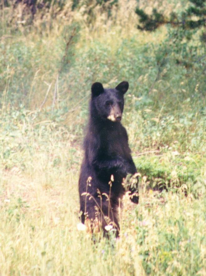
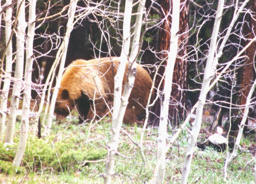
Black bear (Ursus americanus) have been reported with increasing frequency in the area as the density of residences has increased. Trash pickup, new in the past several years, insures that garbage is left outside, creating a powerful attractant for bears. Pet food, bird feeds, and fruit-filled compost piles have proliferated, while the opportunities for wild foraging have decreased as more people have moved into the area. This has resulted in more bear sightings, unfortunately often on porches or in yards, where property damage has occurred. This increase in sightings does not necessarily imply an actual increase in the population of black bear. Increasing human presence coupled with a year or two of decreased berry production on the remaining open lands may have produced the apparent increase. Numbers reported in the 1995-97 Magnolia Wildlife Inventory are probably lower than the actual incidence of sightings. The first few "bear incidents" are enthusiastically reported by area residents. As the summer wears on, the novelty of the incidents decreases, and thus, the reporting decreases.
In the summers of 1995-1997 PUMA documented a minimum of seven individual bears, based on descriptions of size, color, and simultaneity of sightings. Sows have been reported with one and two cubs.
It is not known where denning occurs. Areas on the northern sides of Twin Sisters Ridge, Winiger Ridge, and to the south of Winiger Gulch are possibilities. There is also evidence of considerable black bear utilization in the central part of the Platt-Rogers Memorial Park (Hallock 1997a). The entire Planning Area is considered Black Bear overall range and summer concentration area (CDOW 1997).
Large predators which occur in the Magnolia area are mountain lions (Felis concolor), coyotes (Canis latrans), and bobcats (Felis rufus). Populations of the two former appear to be healthy, with the lion population high in Boulder County compared to historical levels. There are several sightings of lions during every month of the year. Coyotes are frequently seen and heard throughout the area. Several pair with pups are reported each summer. Bobcats (Felis rufus), a Boulder County sensitive species, are also seen frequently, and the population seems to be stable.
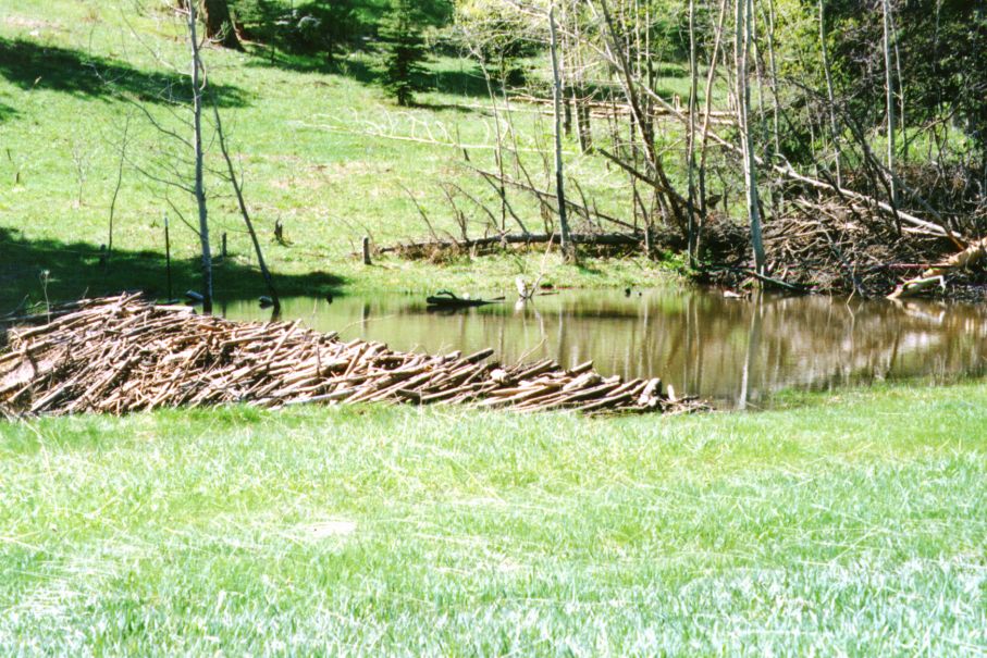
Beaver (Castor canadensis) are largely responsible for creating and maintaining ponds and willow shrublands, which provide extremely important habitat for a wide variety of animal species. Densities of breeding birds in willow shrublands are very high relative to other mountain habitat types, and several species of birds are found only in this habitat type (Hallock et al. 1986). Beaver also slow water flow in streams, thereby raising the water table and reducing the velocity of spring runoff. The dammed areas eventually silt up, creating rich meadows and, in the long term, new forest land. The beaver is listed as a category III mammal of special concern in Boulder County (species undergoing long-term, non-cyclical population decline).
 |
|
Figure 5.6 A beaver pond in the
Lazy Z area of Magnolia
|
Beaver were present on the Kellogg Ranch (on the southeast side of Magnolia Road near the 8 mile marker), and on the adjoining National Forest land along Forsythe Creek to the east, until the summer of 1967 or 1968. Remnants of some of their dams are still visible. There were so many beaver that a decision (involving both the private owners and the USFS) was made to cull them. Unfortunately, in the process all were destroyed. Around 1990, the Kelloggs attempted to reintroduce beaver on the ranch. Despite the owners’ best efforts, the animals promptly migrated down the creek to the next private property where there was a large pond. Lodge building activity ensued, plugging the two large metal pipes that comprised the overflow for the pond. The beavers disappeared by the end of the next summer.
Although there has been no evidence of beaver activity in that particular area since, there is now beaver activity on private land in the creek running through Winiger Gulch. The activity also extends onto USFS land. There are about 6 dams, one or two lodges, and numerous cut aspen, some large. One of the affected property owners believes that the beavers have been present in this new area for several years.
At least one pair of muskrat (Ondatra zibethica) has been seen on the pond in Stilson meadow for the past 4 years. Successful breeding has not been documented.
Gray Fox (Urocyon cinereoargenteus) has been sporadically reported in the Planning Area each of the past three years of the Magnolia Wildlife Inventory.
In general, small mammals in the Front Range are poorly studied and tend toward habitat specialization, making them important indicators of specific habitats and faunal communities. All of these species need further survey work to determine their extent and status in the Planning Area.
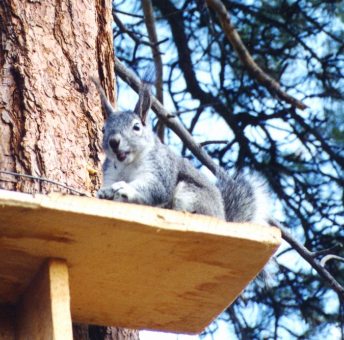 Abert's
squirrels (Sciurus aberti) are listed as a mammal of special concern
in the Boulder County Comprehensive Plan (S IV-species of restricted habitat).
These are large tree squirrels, distinguished by the tufts of fur which extend
out from their ears. They are limited to ponderosa pine forests in the mountain
regions of western North America. They are diurnal and active year round; even
in severe winter weather they leave their nests for short times to feed. Mating
is asynchronous and occurs between February and June. One litter is produced
after a 30 day gestation. Abert’s Squirrels are considered to be non-territorial;
home ranges are large and there is considerable overlap among individuals in
a population (Armstrong 1987). All nests are constructed in ponderosa pine trees,
usually in the upper one-third of the canopy. They have been common in the Magnolia
area; however, anecdotal evidence indicates a decline in population over the
last five years or so. Causes are not clear.
Abert's
squirrels (Sciurus aberti) are listed as a mammal of special concern
in the Boulder County Comprehensive Plan (S IV-species of restricted habitat).
These are large tree squirrels, distinguished by the tufts of fur which extend
out from their ears. They are limited to ponderosa pine forests in the mountain
regions of western North America. They are diurnal and active year round; even
in severe winter weather they leave their nests for short times to feed. Mating
is asynchronous and occurs between February and June. One litter is produced
after a 30 day gestation. Abert’s Squirrels are considered to be non-territorial;
home ranges are large and there is considerable overlap among individuals in
a population (Armstrong 1987). All nests are constructed in ponderosa pine trees,
usually in the upper one-third of the canopy. They have been common in the Magnolia
area; however, anecdotal evidence indicates a decline in population over the
last five years or so. Causes are not clear.
Two bat species of concern are potentially present in the Magnolia area. Thompson's big-eared bat (Plecotus townsendii subsp. pallescens, G4T4 S3, Federal C2) has been documented in a nearby area in 1959 according to the Colorado Natural Heritage Program database (CNHP 1996). Long legged myotis (Myotis volands, also Category 2 on the federal register) was netted on the Reynold's Ranch property in a brief survey in August, 1996 by Dr. Rick Adams and Mark Tracy of Colorado State University.
Birds have been documented by PUMA within the Planning Area by means of the three continuing programs described below.
The Colorado Breeding Bird Atlas protocol has been used to search for breeding birds within the Magnolia Planning Area. The area was divided into 12 blocks, and groups of 1-4 volunteers visited each block a minimum of 3 times, for a minimum total of 12 hours between 1 June and 15 August 1997. Volunteers visited each major habitat type within each block at least once. These 1997 breeding season observations were supplemented by reports submitted by local residents during the 1995 and 1996 breeding seasons and by results of breeding bird surveys conducted on the Platt-Rogers and Reynolds Ranch Open Space parcels by Dave Hallock during 1996.
 |
|
Figure 5.8 Great Horned Owl (insert:
chick)
|
A total of 97 potential breeding species were observed within the study area during the 1995-97 breeding seasons Individual habitats supported the following numbers of species: aspen 24, coniferous forest 63, grassland 16, lakes and ponds 3, riparian woodlands and shrublands 41, xeric shrublands 4, rock and talus 9, and other wetlands 9. The list of potential breeding birds within the study area includes 16 Boulder County Avian Species of Special Concern (Boulder County 1993). Due to their rarity or their dependence on isolated or endangered habitats, these species may be particularly vulnerable to environmental disturbance. The results of the breeding bird survey and individual species accounts for the species of concern are found in Appendix 5.5.
PUMA volunteers conducted a survey for Goshawk and Flammulated Owls during the summer of 1996. In addition, members have reported sightings of wildlife in the area, including around their homes, since May of 1995 (for methodology see Section 5.2). A compilation of the avian species sighted, divided as to year and season of sighting, is included in Appendix 5.4.
This four season bird count has been conducted in Boulder County for the past fifteen years. Much of the western half of the Planning Area is included within the count boundary and most of the observations made in the fifteen year summary are pertinent to this area (Hallock 1997b). Some of the most relevant findings include:
Over the four seasons, dominant numeric species include mountain chickadee1, dark-eyed junco and pine siskin. American robin and yellow-rumped warbler are also abundant except for winter.
Within the mountain landscape, members of the corvid family (jays, crows, magpies, ravens) appear to be increasing in number and are more widespread. This is most evident with American crow.
During the past five years (1992-1996) there were numeric declines for several of the long distance migratory species, including spotted sandpiper, western wood-pewee, willow flycatcher, dusky flycatcher, horned lark, warbling vireo, Virginia's warbler, Wilson's warbler and western tanager. Among resident species, evening grosbeaks have shown steady decline.
Several resident species are increasing, including mountain chickadee, red-breasted nuthatch, white-breasted nuthatch, pygmy nuthatch, brown creeper, and golden-crowned kinglet. Several of the short to moderate distance migratory sparrows have also shown steady increases, including fox, song, Lincoln's, and white-crowned sparrows.
The declines and increases in numbers of those species noted in the Indian Peaks Bird Count are directly reflected by the observations of Magnolia area residents. However, in the Indian Peaks Bird Count, urban/agricultural species (brown-headed cowbirds, starlings, and Brewers Blackbirds) have had variable counts, while they appear to be unchanged during the studies conducted by PUMA.
The boreal toad (Bufo boreas) (G5T2QS1, Federal C1, Forest Service sensitive species) has been documented historically to breed at Giggey Lake on Reynolds Ranch. A recent search at this site was non-productive. The toad has been documented in nearby areas in 1994 and 1961 (CNHP 1996). A tiger salamander (Ambystoma tigrinum) was reported near the cistern at High Country Fire Department Station # 4 on Magnolia Road and was documented at Giggey Lake in 1997 (Boulder County Parks and Open Space Department 1998). Northern leopard frogs (Rana pipiens) have not been reported, but are possible in the area. The striped chorus frog (Pseudacris triseriata), a non-sensitive species, breeds throughout the area. There has been no systematic inventory of amphibians in the Planning Area, except for the above mentioned search for the Boreal Toad.
Reptiles found in the Magnolia area are few and have not been systematically studied. The smooth green snake (Opheodrys vernalis) has been seen in the riparian area along the creek draining into Gross Reservoir near Forest Road 359. This species has been watchlisted by CNHP with the state status uncertain and thought to range from rare to common, but restricted. This listing does not imply any immediate threat to the species. The eastern fence lizard (Sceloporus undulatus), bull snake (Pituophis melanoleucus), and western terrestrial garter snake (Thamnophis elegans) can also be found in the Planning Area. No rattlesnakes have been reported. Further inventory needs to be done.
Fish population data was collected by the Colorado Division of Wildlife near Pinecliffe in 1991 on South Boulder Creek (Miller Ecological Consultants Inc. 1997). Predominate species were rainbow trout (Oncorhynchus mykiss) with smaller numbers of brook trout (Salvelinus fontinalis) followed by cutthroat trout (Oncorhynchus clarki). Longnose sucker (Catostomus catostomus) and white sucker (Catostomus commersoni) were also collected. Most of the trout were less than 25 cm in length. Estimated biomass at Pinecliffe for total trout is approximately 17 pounds/acre. This level is typical of population biomass for other high elevation streams in the Front Range. Fish populations in Winiger Gulch and Forsythe Creek have not been studied.
The sharp sprite (Promenetes exacuous) was collected at Giggey Lake from 1963-1967 (Boulder County Parks and Open Space Department 1998). This species is considered imperiled in Colorado (CNHP 1996). Many species of freshwater mollusks have been collected at Giggey Lake (Wu 1989).
Butterflies were partially inventoried during the summer of 1997 by a team headed by Janet Chu. Additional field work is planned. As determined by CNHP, there are certain endangered species of butterfly and moths which are probable in this area, but none have been identified as yet.
Both the state and the USFS consider Boulder County to be potential, but unoccupied habitat for lynx and wolverine. There have been three reports of lynx (Felis canadensis, State listed threatened or endangered species) sightings in the Twin Sisters area, but these have been unconfirmed by other observers, photos, or physical evidence. PUMA plans to consult with the CDOW about a protocol for placing "hair snares" or otherwise attempting to confirm these sightings. There have been two unconfirmed reports of wolverines (Gulo gulo,), one on August 14, 1989 at mile marker 4 on Magnolia Road, and one in the Frontier Road area at about the same time.
Table 5.4 in Appendix 5.5 presents an avian species of concern list specific to the Planning Area. This list is derived from determinations made by County, state and federal agencies, and environmental organizations.
1 Common names of birds follows the American Ornithologists Union 1983 Checklist of North American Birds (as revised).
 |
 |