

The typical landscape of the Planning Area is rolling foothills dissected by Middle and South Boulder Creeks and tributary drainages. Outcrops of granitic bedrock are ubiquitous, with significant rock formations including Eagle Rock, the summit of Twin Sisters Peak and adjacent cliffs, Forsythe Rock (Figures 8.1 and 8.2), and the canyon wall north of South Boulder Creek. Vegetation cover is dominated by coniferous forest balanced by the intermittent occurrence of meadows.
Important meadows include Stilson Meadow along both sides of Magnolia Road, the southern portions of Twin Sisters Ranch, Scates Ranch north of Magnolia Road, and Reynolds Ranch along the western portion of Magnolia Road. All of these meadows include limited wetland or riparian ecosystems, and several of them have aspen stands that transition from the open grasslands to dense coniferous forest. Views from these meadow sites include forested slopes and rock outcrops within and adjacent to the Planning Area, as well as some of the high peaks of the continental divide. And they also include remnant structures from historical ranching operations.
Table 8.2 Scenic Assessment of the MEPP Planning Area
| Geographic Location | Scenic Attractive-ness Class | Scenic Integrity | Level of Public Concern and Value | Visual Absorption Capability |
| Hawkin, Keystone, and Calhoun Gulches and Lower Magnolia Drive | Distinctive to Typical | General: High Rural Development: Moderate | High | Intermediate to Low |
| Platt Rogers Memorial Park, Rogers Property | Distinctive to Typical | General: High Logging Sites: Moderate | High | Intermediate to Low |
| Twin Sisters Peak | Distinctive | High | High | Intermediate to Low |
| Central Magnolia Drive, Stilson Ranch, Twin Sisters Ranch, Scates Ranch, Forsythe Rock | Distinctive to Typical | General: Moderate Stilson's Meadow, Scales Ranch, Forsythe Rock: High | High | Low |
| Boy Scout Trails Area | Distinctive to Typical | General: High Logging Sites: Moderate | High | Intermediate |
| Winiger Ridge, Forsythe Canyon, and Winiger Gulch | Distinctive | General: Moderate to High 4WD Sites: Moderate to Low | High | Intermediate |
| Lazy Z Subdivision and County Roads 97 and 97E | Typical | General: Moderate County Road 97: High | High | Intermediate |
| Reynolds Ranch west to Peak-to-Peak Highway | Distinctive to typical | High | High | Open Areas: Low Forested Areas: High |
| South Boulder Creek | Distinctive | High | High | Intermediate to Low |
Scenic resources are grouped into basic geological, vegetative, and cultural categories and evaluated by standardized criteria as developed by the federal government. A summary of scenic resource categories, with evaluations, for the Planning Area is presented above in Table 8.1. Table 8.2 is a scenic assessment of the Planning Area by geographic location. Since these geographic areas may include a variety of landforms and vegetative cover types, the evaluation for a given location may fall within a wide range of values. Definitions of the scenic assessment categories, evaluations, and values are found in Appendix 8.2.
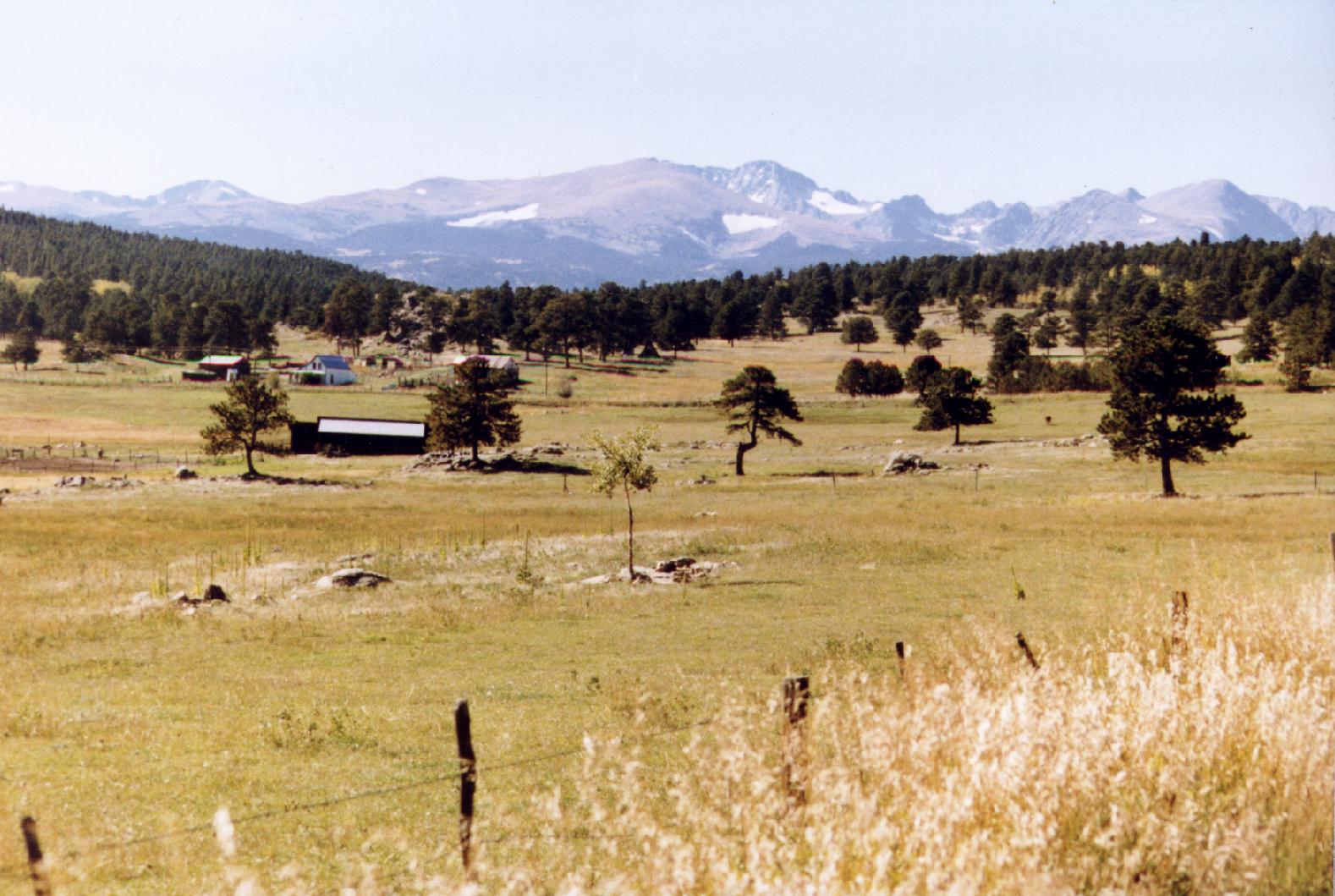 |
| Figure 8.3 Stilson's Meadow from Twin Sisters Ranch road. Note the historic ranch buildings. The high peaks of the Continental Divide are in the far background. |
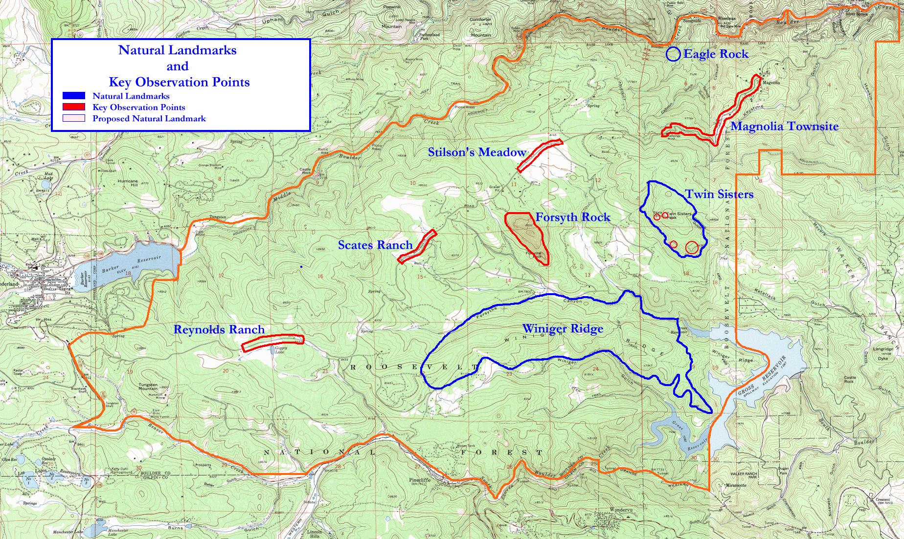
Key observation points with panoramic views include:
1. the three, large meadow sites along Magnolia Drive including Stilson's Meadow (Section cover, Figures 8.1 and 8.3), Scates Ranch (Figure 8.5), and Reynolds Ranch (Figure 8.6)
2. Magnolia Drive from the Magnolia townsite west to the vicinity of the Kekionga Mine (Figure 8.7)
3. the summit rock outcrops of Twin Sisters Peak
4. the top of Winiger Ridge
Observation points 1, 3, and 4 include views of much of the Planning Area as well as background views of the alpine peaks of the Continental Divide and other major summits of the Front Range. Observation point 2 also includes panoramic views of the plains of Boulder County (Figure 8.8). These key observation points are displayed in Figure 8.4.
 |
|
Figure 8.4 Natural Landmarks and Observations Points
in the Study Area
|
 |
 |